Last week I posted my article about one of the final proposals in the Shore to Core competition. I got quite a bit of feedback on the article, so I wanted to make some clarifications.
1. There are two finalists, I am in the process of writing an article about the second finalist, but I have not had the time to complete it. Hopefully I’ll finish it over the weekend, so stay tuned. Click here to view both proposals on the official website.
2. I’ve been told that the designs are just starting points, not final decisions on what we want our waterfront to look like over the next 20 or so years. Once a design is picked it will be used as a starting point for future decisions.
If you have comments please send them to cra@wpb.org
There is more information on display at the City Hall courtyard, please stop by and take a look.

Now we take a look at the other finalist in the competition. New York-based Perkins + Will.
I am including exceprts from their proposal below. Click here to view the full proposal.
Vision for a Thriving West Palm Beach
This proposal transforms West Palm Beach’s waterfront into a dynamic social and environmental space, rethinks the city’s streets and alleys as destinations in their own right —not just conduits for cars— and envisions mundane architecture, like parking structures, as opportunities to create community.
When West Palm Beach adapts, it thrives.
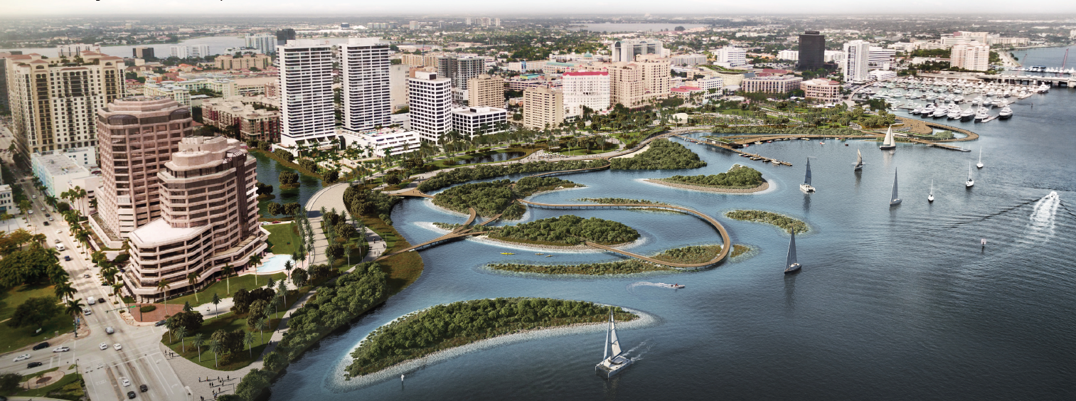
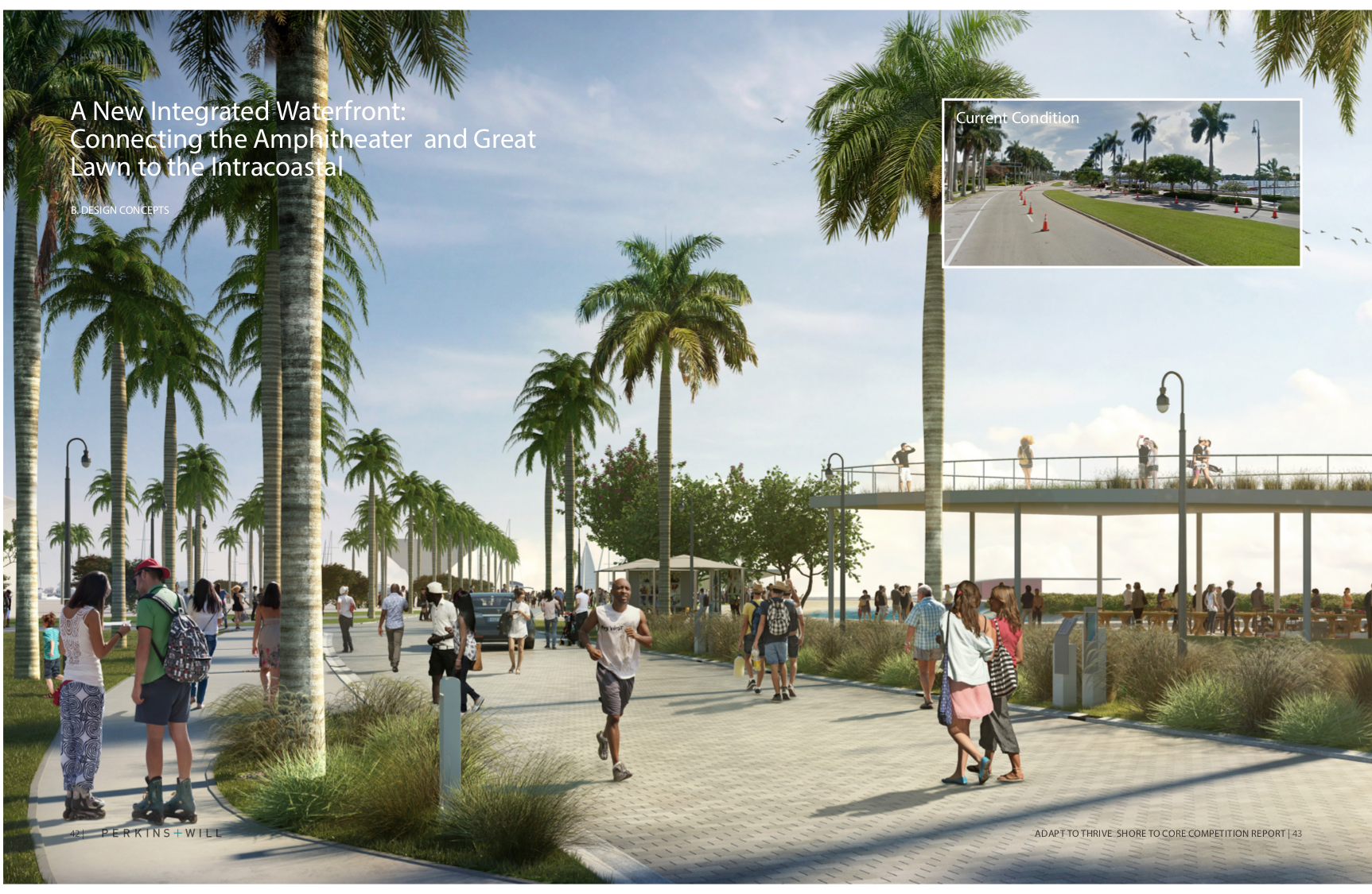
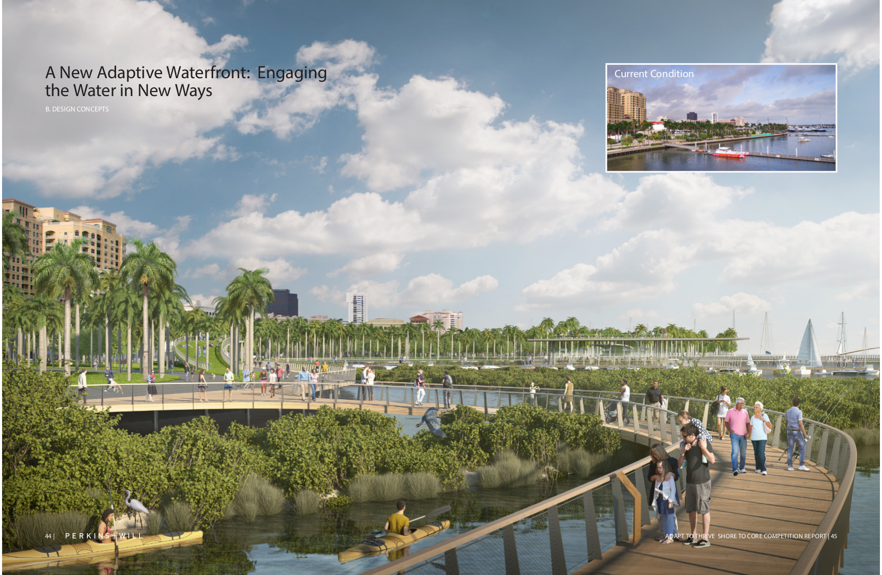
A new Waterfront
Waterfront Cities are Defined by the relationships between People and Water.
The waterfront is WPB’s connection between land and sea. Today’s waterfront users include boaters, residents and tourists that come into to the city from the waterside – its docks and piers – as well as, local residents and thousands of visitors who descend on the waterfront for its signature events, SunFest and Palm Beach International Boat Show.
The goal of our proposal is to make the waterfront an even more attractive place to stroll, jog, cycle, boat, and enjoy.
Waterfront dining options are provided at a myriad of levels: On the pier, on a rooftop garden, and on the mangrove island.
New floating waterfront amenities include over-the-water boardwalks, restaurants, and additional daydocking that is integrated into and between the existing floating piers.
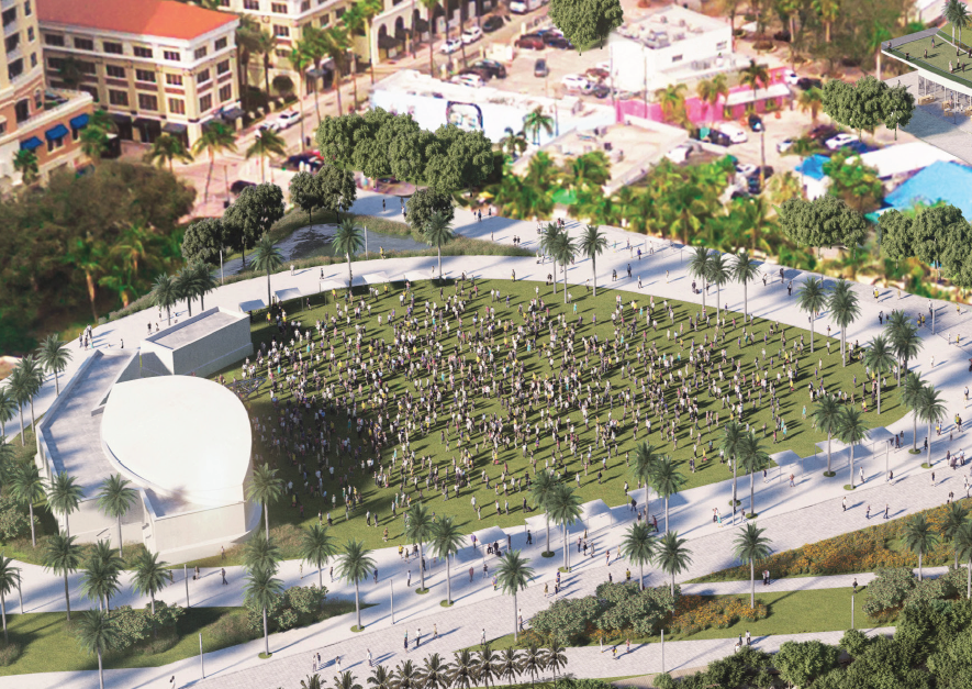
A redesigned waterfront with a new waterfront pavilion located on land acquired from the redesigned Flagler Street unites the formerly separate downtown spaces: waterfront promenade, amphitheater, and Great Lawn.
A new waterfront community pool allows access into the water as part of the waterfront experience.
New waterfront steps allow access into and observation of the daily high and low tides, the monthly effect of the moon on the tides, and the slowly rising seas.
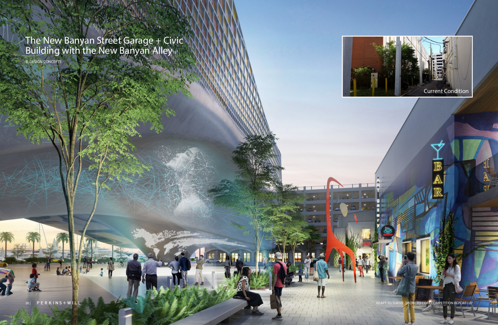
A new Banyan Street Garage
The underutilized Banyan Garage will be transformed into a new civic icon for the city. The building and its site continue and incorporate the overall project theme of Adaptability by providing new and unique spaces that are flexible enough to fit the social, economic and environmental needs of the community.
This civic building will become a magnet for social interaction by creating a ground level “public social space”, “flex-space” floor plates (providing +/- 300 parking spaces or +/- 100,000 gsf of event space) and a rooftop public “sky garden” – each creating a wealth of new opportunities for residents and visitors to experience downtown and the waterfront.
A new Meyer Amphitheater
The Meyer Amphitheater (with its +/-10,000 sf band shell and +/- 1 acre sloped lawn) is host to a handful of special events throughout the year. Although the band shell’s size is not readily suitable for either large or small events, its prominent location and open lawn space provides downtown residents with a place to sit, picnic, and enjoy a more passive downtown park that complements the more active, event friendly great lawn a block away.
New views into the amphitheater and out to the waterfront are created by removing the existing berm along Flagler Street and extending the range of the amphitheater out toward the waterfront promenade.
Regrading the amphitheater grounds to more seamlessly integrate into the redesigned waterfront experience – sloped along Datura Street and open to Flagler Street and the waterfront.
Preparing for rising Seas
The shape of the waterfront has changed only slightly over the past 100 years. Some new areas to the south were created to provide additional public waterfront, while new areas for development were created to the north. Some areas were removed entirely: The 1907 map shows the city’s land mass extending into the Intracoastal, where the South Cove Islands are today.
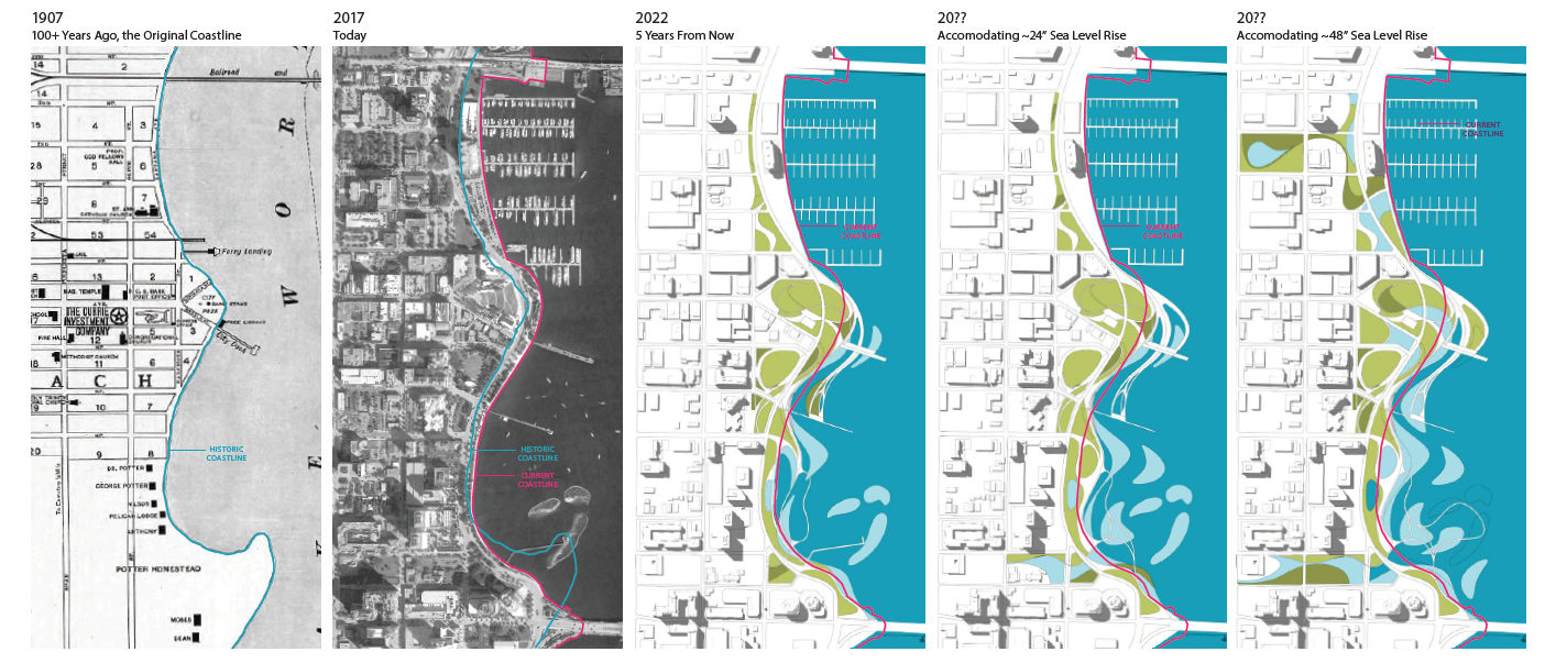
The character of the current water’s edge is dominated by a linear, concrete bulkhead interrupted only occasionally with access to piers and boat docking slips. This bulkhead solution replaced the original, more natural riparian ecosystem that defined the water’s edge and has created a barrier between people and their ability to interact directly with the water.
The reintroduction of habitat islands, mangrove plantings, and low marsh areas provide opportunities for environmental education and play an important role in connecting the upland area with the aquatic habitat. The introduction of a beach, water terraces, and berm structures help to restore habitat by simulating the functions of the original ecosystem while providing greater opportunities for people to engage with the water.