This article started as some research into the history of the upcoming 4-to-3 lane South Dixie Highway road diet. As I looked at the decade of work and half-dozen studies that has gone into this project the article expanded.
All the work was towards a single goal: Moving South Dixie from a Highway to a Neighborhood road.
“We need a plan that will be implemented and will make the South Dixie Highway Corridor the vital place it once was. One of the biggest challenges the plan should address is that due to the proximity of I-95, the corridor no longer functions as a highway. It is a neighborhood road.”
Late District 5 Commissioner, Bill Moss in 2012
This process that started in 2012 has included interviews with hundreds of neighbors and local organizations and businesses to bring it to where we are now.
Please review the information below, attend the FDOT meeting on the 28th of January.
All the studies that I reference are available for download at this link.
Table of Contents
2012 – ULI Technical Assistance Panel
2015 – Neighborhood Intervention
- Community Feedback
- Community Presentation
- The TCRPC Report
- Report Highlights
- What does a 4-to-3 Lane Diet look like?
- How bad will a 4-to-3 Road Diet make the Traffic?
- Who supports the plan
2017 – Palm Beach TPA US-1 Multimodal Corridor Study
2018 – The Traffic Study
2019 – City of West Palm Beach South Dixie Highway implementation Plan
2019 – FDOT Approves 4-to-3 Lane Elimination
2020 – FDOT Public Meeting with West Palm Beach residents
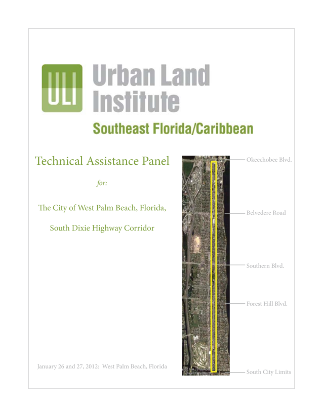
2012 – ULI Technical Assistance Panel
My memory of this process starts in 2012 when the city spent $15,000 to bring in a “Technical Assistance Panel” (TAP) from the Urban Land Institute to study the highway.
The Goals
“The city’s goal for the South Dixie Highway Corridor TAP was to hear from a multi-disciplinary panel of seasoned experts what strategies can be used to assist with the revitalization and improvement of the entire corridor – ideas for what the corridor could be like and a set of near-and longer-term steps and financing mechanisms to start making that future possible.”
Jeri Muoio, Mayor, City of West Palm Beach
The panel was asked to focus on both near- and longer-term steps. Those steps were to include ideas for what the corridor could be like in the future as well as the implementation strategies necessary to make that future a reality (rather than just another plan sitting on a shelf).
Community Feedback
The public comments offered at the December 6, 2012 workshop built on and reinforced a series of South Dixie Highway Visioning Groups Meetings held from the fall of 2009 to the fall of 2010. Those workshops led to a vision statement:
“South Dixie Highway should support a vibrant business community that serves both the adjacent neighborhoods and regional customers and provides a mix of retail, dining, art, antique and office uses, with adequate parking for visitors, safe pedestrian crossings, and linkages to the surrounding neighborhoods. South Dixie Highway should be tree-lined and contain landscaped properties with attractive buildings that are consistent in scale and mass.”
The TAP amalgamated the public comment to these point.
- South Dixie Highway is now a neighborhood road and should be treated as such. Currently the corridor is a barrier to pedestrians. The big issue is making the corridor walkable. Agencies need to work together to do that.
- We want a corridor that is a shopping destination – an area that people go to, not drive by. Th at means a place that feels safe and is easy to park in and spend a day strolling along and across the corridor.
- The corridor is a unique area. It is composed of an interesting mix of architectural styles and uses that distinguish it from homogeneous areas to the west.
- A plan for the corridor needs to inspire action and not just focus on the little things. It also should give businesses the flexibility to respond to changes in the market.
- A plan for the corridor needs to be coupled with a way to fund it. That should include big impact actions early on to show progress.
- It is time to stop talking and act. For that, we need strong leadership.
The Proposal
The 2-day work session developed a report that laid out the following priorities.
- Put in place the public and private financing and the governance structure that will lead to successful implementation.
- Provide an adequate supply of parking in the right places.
- Lower the speed of traffic and make it easier for pedestrians to cross the street.
- Select streetscape improvements that contribute to creating a walkable environment and enhance the corridor’s identity.
- Develop a compelling corridor vision, brand, and coordinated marketing plan.
- Address code enforcement and physical upgrades for currently allowed uses and enhancement of properties that are less visually appealing and/or not contributing to meet corridor goals.
Read the full report here.
The Response
This study covered the entire length of South Dixie Highway, from Okeechobee to Lake work. For 2 days worth of work, it was limited in scope – and members of the commission felt that it did not provide a specific enough actionable items.
“I like the direction they’re heading in. Although, I don’t care what plan you come up with, if you can’t pay for it, it aint gonna work. It looks like there’s a commitment from the mayor and her staff to not just let this die on the shelf somewhere, which is encouraging.”
Commissioner (now Mayor) Keith James
To further the project, Mayor Jeri Muoio put together the South Dixie Corridor Implementation Strategy Committee – which presented their findings to the City of West Palm Beach in August of 2014.
As of publishing date I am not able to locate a copy of this report, but will update this article with a link to it as soon as I have it.
2015 – Neighborhood Intervention
Three years have now gone by since the Urban Land Institute released their report.
The Norton Museum is getting ready for what will end up being a $100 million improvement project, and the El Cid Neighborhood Association, & local businesses are tired of waiting.
“Faced with speeding cars, glaring sun, treeless sidewalks and a dearth of parking spaces, a coalition of neighborhood groiups and shopkeepers has commissioned professional planners to redraw the streetscape to satisfy the conflicting needs of car and pedestrian, commerce and community.”
Tony Doris, Palm Beach Post April 13 2015
Like always, the big issue was who is going to pay for this.
The neighbors, lead by Paula Ryan (who would later become City Commissioner), and local businesses raised $115,000. The firm contracted to do the work was the acclaimed Palm Coast Regional Planners and local resident Dana Little.
The project area was chosen to be from Okeechobee Blvd to Ablemarle Road.
“It’s always been an issue for people who live off of South Dixie. By us taking the initiative and agreeing to raise money and working in a collaborative partnership, we are able to get a solid plan … Dixie Highway is not always going to look the way it looks today.”
Paula Ryan in a Palm Beach Post Interview
There were many ideas that were to be studied. But from the beginning it was clear that a 4-lanes to 3-lanes “road diet” of South Dixie Highway would be the center piece of the project.
“The road can’t be everything to everybody. It can’t have parking on both sides and accommodate four lanes of traffic. Maybe it can have parking on one side, and three lanes with a turn lane. The way we think that highway is best served is to make it as much a neighborhood road as possible.”
Will Corrente, Posh Pet Hotel business owner in a Palm Beach Post interview.
Community Feedback
On March 28th a charrette was held at the Norton Museum of Art to kick off the project.
This presentation was given by Dana Little to present the opportunities and the scope of the work that was to be accomplished at the charrette.
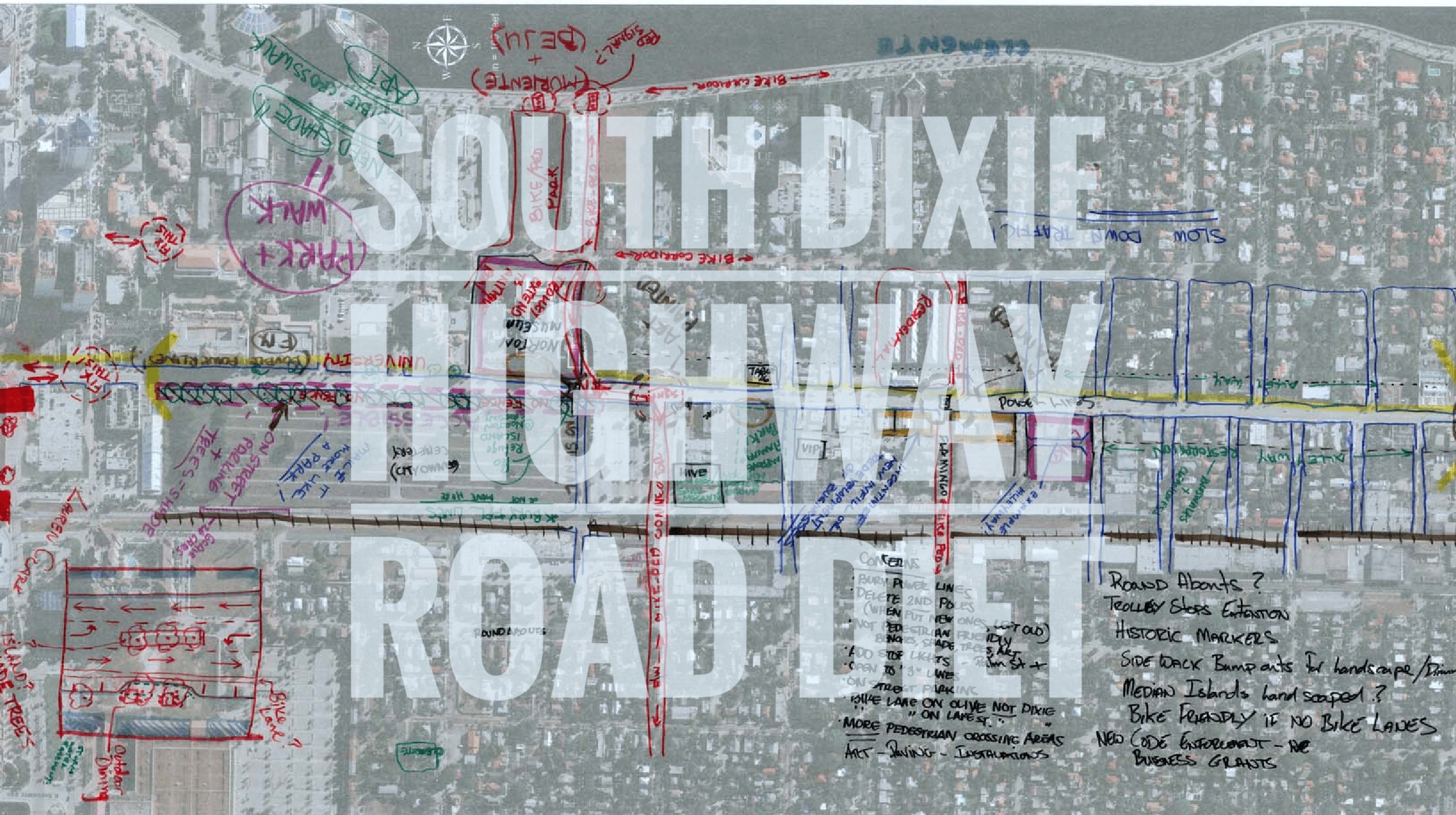
As part of the charrette, the attendees wrote their issues with the current configuration of South Dixie Highway and noted possible options as to how to improve the road.
- Reduce traffic lanes to 3
- Add trolley line to downtown
- Bike Lanes
- Use of Alleys
- On / Off street parking
- Use roundabouts as alternative to signals
- Encourage outdoor seating
- Encourage park usage
- New crosswalks
- Safe sidewalks
- Bulbout platers
- Shade trees
- Bring back resident’s destination retail
- Add drinking fountains
- Change the speed to 25mph
The maps were signed by the attendees of the event. Click on one of the images below to get a better view of the maps created at this event.


Residents signed wrote their comments on the maps, and signed their names.
Community Presentation
During it’s development the project was presented to various neighborhood groups, and comments were taken into consideration.
Here are some photos from the meeting held at Palm Beach Dramaworks for downtown residents on August 18th, 2015.
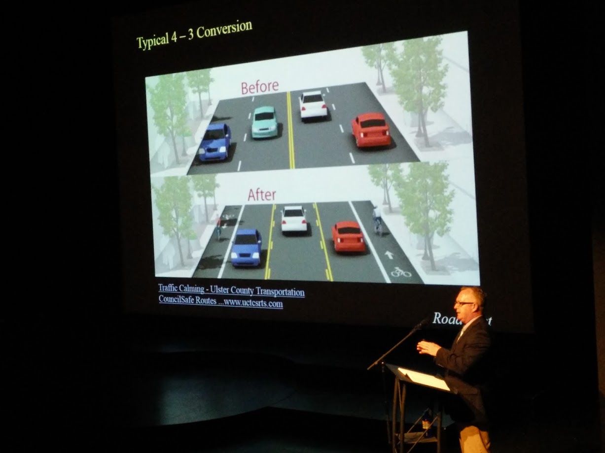
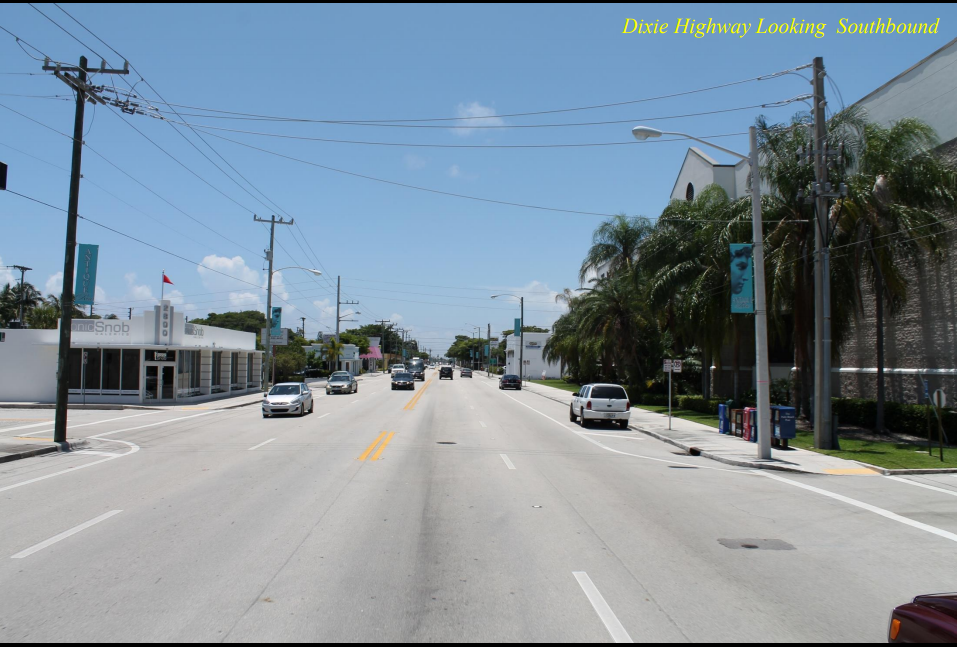
Typical 4-to-3 road diet 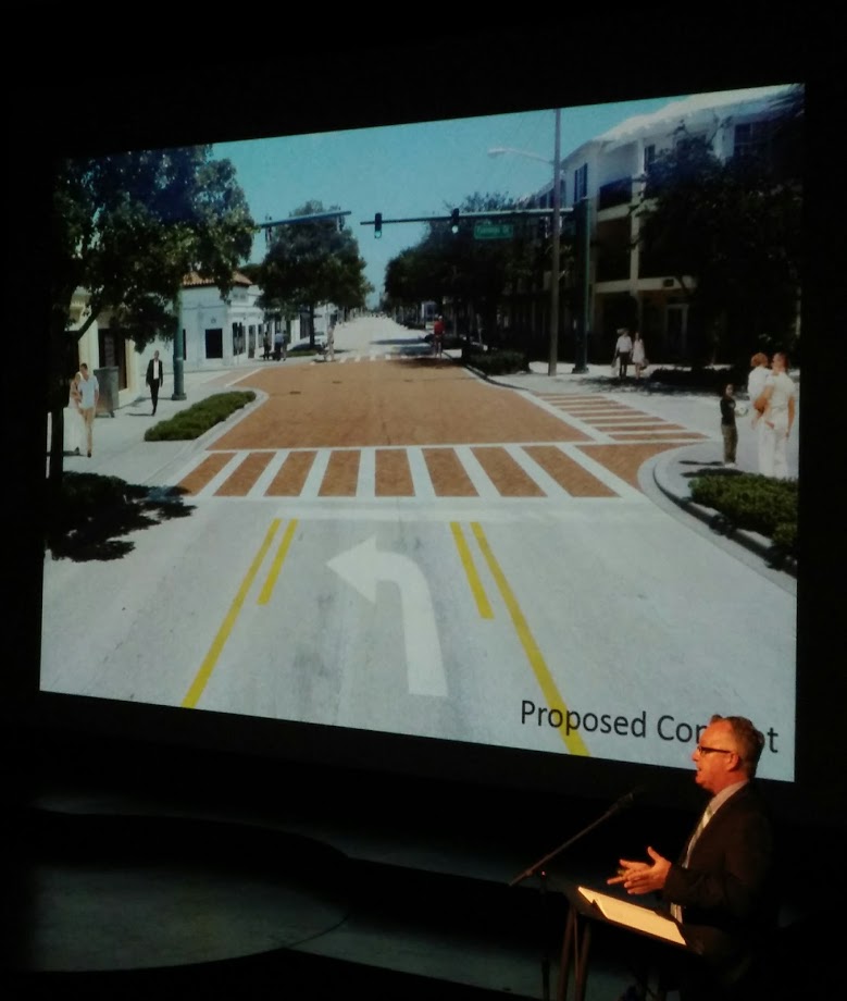
Dana Little displaying a rendering of the Flamingo & Dixie intersection after a 4-to-3 road diet 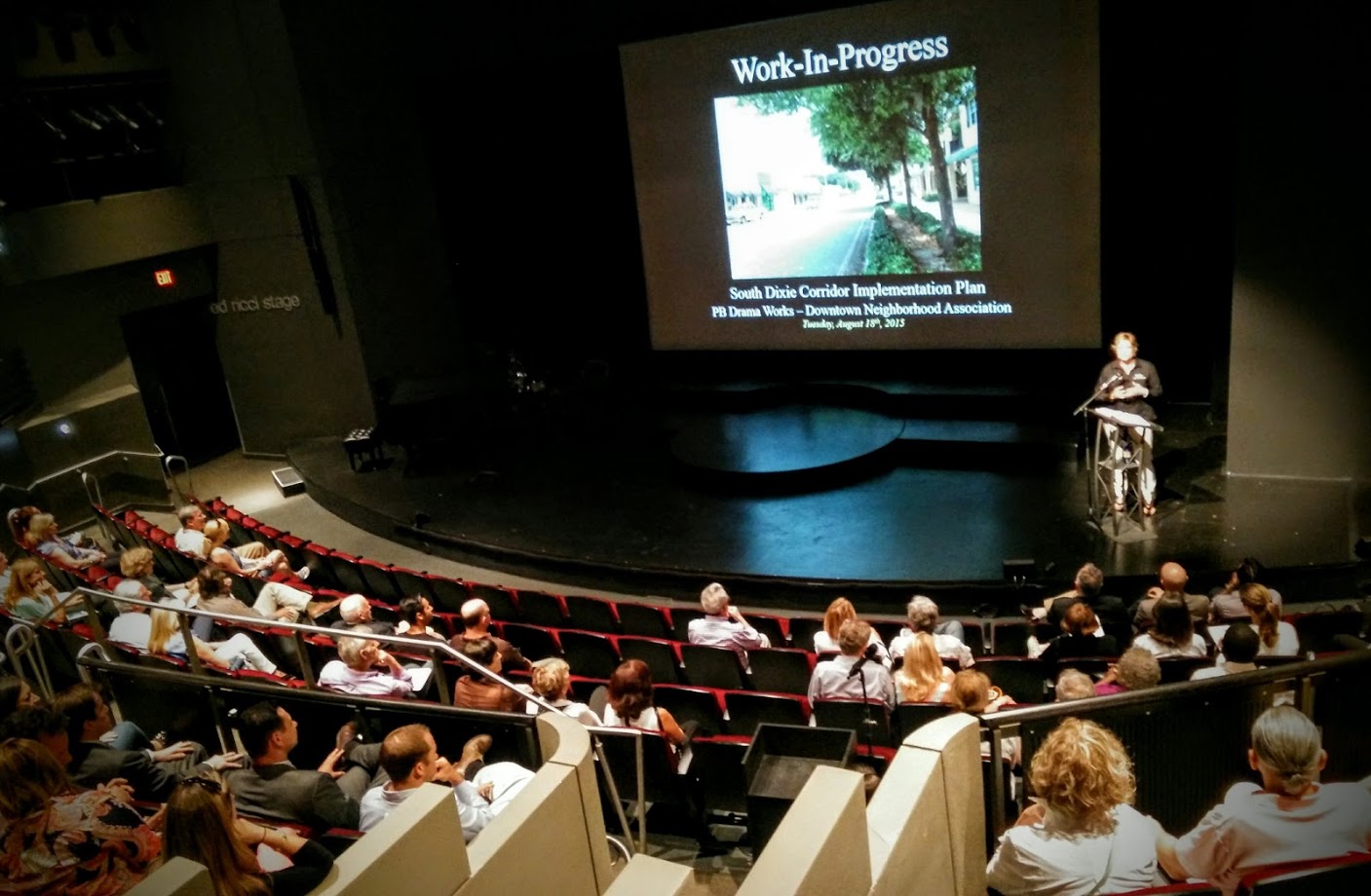
Commissioner Paula Ryan Introducing the Study
The Report
Once the charrette was complete, TCRPC conducted interviews with stakeholders and developed the “West Palm Beach South Dixie Corridor Master Plan”.
In October 2016 the report was ready.
The process and work is outlined in this web page.
The West Palm Beach South Dixie Corridor Master Plan is a coordinated effort between the City of West Palm Beach, the Palm Beach Metropolitan Planning Organization, and Treasure Coast Regional Planning Council. This effort is made possible through the efforts of El Cid Neighborhood Association, the Flamingo Park Neighborhood Association, the Norton Museum of Art and Palm Beach Atlantic University.
In addition, the following are project partners: Grandview Heights Neighborhood Association, Buccan, Bruce Oullette and Associates, Hall Hardware, Terrace Mountain Investors, Chamber of the Palm Beaches, Palm Beach Motorcars, Rob Revely, Johnson Framing, Table 26, McCann Design Group/HIVE, Very Important Paws, Great Wraps, Brian Guralnick, Cosmo Dischino, Antiquie Row, Valore Group, Serenity Tea House, Ben McFarland, Fleur Cinque, Coldwell Banker, El Cid Animal Clinic, Citrus Salon, Lotus Hair Salon, and Raphael Clemente.
Treasure Coast Regional Planning
Report Highlights
The 4-to-3 road diet was the highlight of the report. Primary reasons were safety, and slowing down traffic to create the desired “Neighborhood Street”
However it wasn’t the only proposal, as additional suggestions were made.
- Consolidate Curb-Cuts to Make More Parking
- Create “Pocket Parking Areas”
- Establish Consistent Streetscape with SHADE TREES
- Enhance Pedestrian Realm and Crosswalks
- Bury Power Lines
- Make The Corridor a “Complete Street”
What does a 4-to-3 Lane Diet look like?
Here are some sets of Before / After renderings that are provided in the proposal.
Dixie at Flamingo Drive 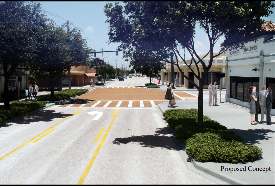
Dixie at Flamingo Drive after Road Diet

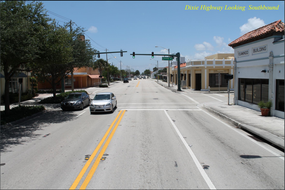
Dixie at Dyer Road – looking South 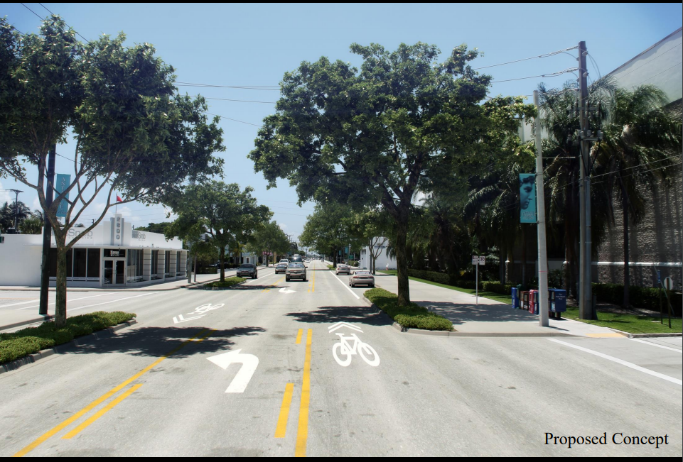
Dixie at Dyer Road – looking South after Road Diet


Dixie at Dyer Road – looking North 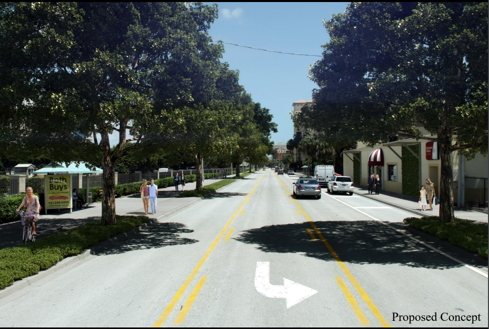
Dixie at Dyer Road – looking North after Road Diet

How bad will a 4-to-3 Road Diet make the Traffic?
Note: This was the actual headline in the report.
First the team looked at traffic since 2005 and determined that traffic on Dixie had decreased between 8.4 and 4.7% (depending on the segment).
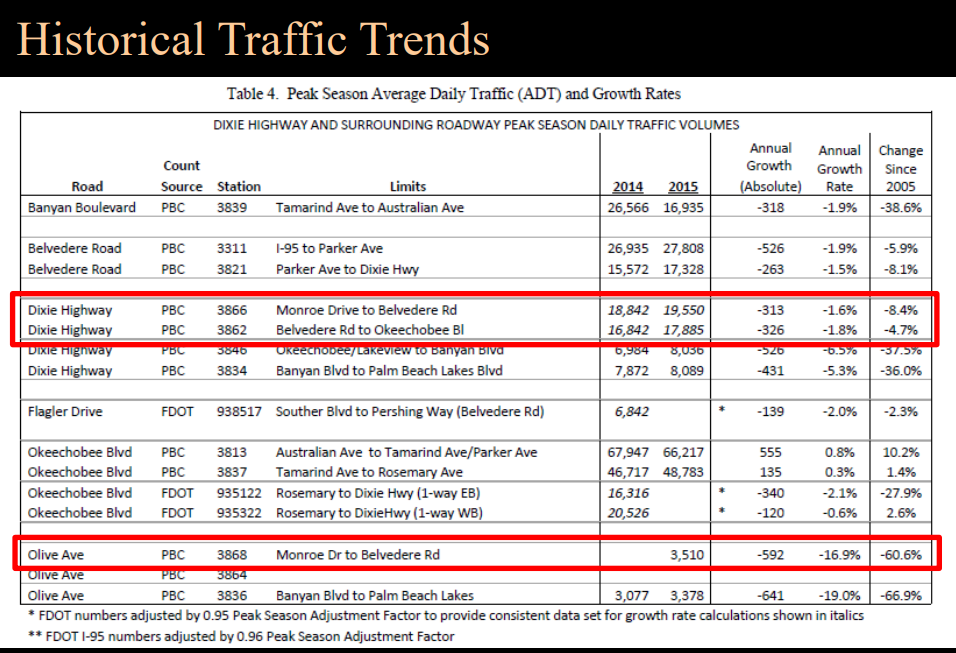
Then they looked forward from 2015 to 2040.
Without any changes to Dixie Highway, the traffic in 2040 will increase from 18,000 Average Daily Trip today to 19,000 trips in 2040. A 5% increase
In a 3-Lane scenario the traffic will decrease 11% with a ADT of 16,000 in 2040.
If we go from 4 lanes to 3 lanes, we will have fewer cars on Dixie.
Where will the traffic go? The answer is basically Parker (1,500), I95 (1,000) and other local roads


Who supports the plan
The report closes with a list of organizations that supported the plan. As of 2016 the following organizations gave their support.
- Downtown Neighborhood Association
- Carefree Theater Project
- City of West Palm Beach
- Flamingo Park Neighborhood Association
- Norton Museum of Art
- Grandview Heights Neighborhood Association
- Mango Promenade Neighborhood Association
- El Cid Neighborhood Association
- Sunshine Park Neighborhood Association
- Palm Tran
Palm Beach TPA US-1 Multimodal Corridor Study
While all of this was going on in the City. In 2017 the County-based Transportation Planning Authority (TPA) was working on a separate study of all 42 miles of US-1 from Jupiter to Boca Raton.
The study encompassed the US-1 corridor in Palm Beach County from Camino Real in the City of Boca Raton to Indiantown Road in the Town of Jupiter. The project corridor is approximately 42 miles in length and runs north-south across 14 local municipalities. This effort included 6 months of public workshops and charrettes.
In August, 2017 the team held charrettes at the City Library to get input from local residents as to how they want to see US-1 (Dixie Highway) grow in the future.


One of the exercises at the charrette was determining what was important to individuals. Each participant was given a list of 11 items and 6 spaces to fill in order of importance.
Here’s my list and an explanation on why these items matter to me:
- Propensity for use: Any project would be pointless if nobody uses it. We need to make sure that the US-1 Corridor is used to it’s fullest.
- Social Equity: The project should benefit all of the residents regardless of their social standing.
- Fill a Gap in the Network: Having a useful network of public transport is very important. This project should prioritize items which give us a complete and usable network.
- Safety: The US-1 corridor is VERY unsafe, there are very few safety and traffic calming features. Even though the speed limit is 35, the traffic often moves 40-50 mph. We need better crosswalks, protected bike trails and sidewalks.
- Economic Development “Placemaking”: Many people look at streets as just a way to get from Point A to Point B. But projects which add more to the streets and give them the ability to become places to themselves, and benefit the stores and neighborhoods around them is a valuable resource.
- Additional Mobility Options: Streets should be multi-modal. Any projects that make our streets a great experience for Cars, Public Transport, as well as Bikers and Pedestrians is important.
Read my article about it here.
The final results of the Multi-Modal Corridor Study were published on their website.
Independent of the West Palm Beach Studies the TPA planned for a 4-to-3 road diet in both on South Dixie highway as well as north of downtown on Broadway.
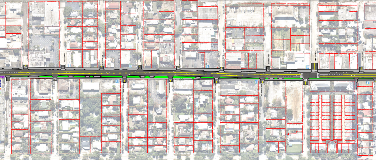
TPA plan for 4-to-3 Road Diet South of Kanuga Drive 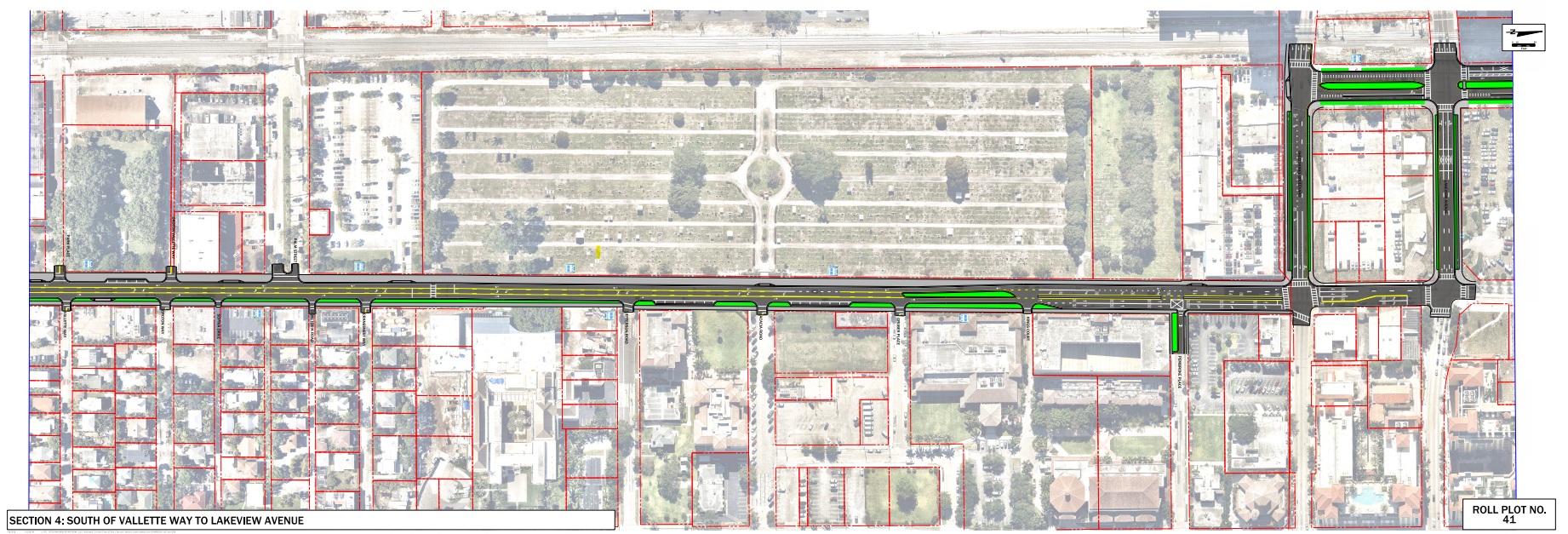
TPA plan for 4-to-3 Road Diet from Lakeview to Valette

The Traffic Study
To make a change as big as a lane elimination a reality a traffic study must be done.
The City contracted MacKenzie Engineering & Planning to do the work.
In partnership with the Palm Beach Transportation Planning Agency (TPA), surrounding businesses, homeowners’ associations, and institutions, the City of West Palm Beach engaged Treasure Coast Regional Planning Council (TCRPC) to investigate the possibility of a lane elimination on Dixie Highway from Albemarle Road north to Okeechobee Boulevard. This section of Dixie Highway has more than a decade of history of City, resident and business involvement to revitalize this segment of road in West Palm Beach. The most recent City efforts resulted in a collaboration with the Urban Land Institute (ULI) convening a Technical Assistance Panel (TAP) to develop recommendations for the corridor based on professional advice and input. The completed report, “South Dixie Corridor Implementation Strategy Committee Report” (TAP report), was completed on August 11, 2014. The lane elimination process is the next step toward furthering many of the recommendation from the TAP report.
This is a pretty technical document but there were several key points.
The Dixie & Lakeview intersection is a problem.
When I mention the road diet, most people point to the congestion on South Dixie Highway and Lakeview.
The traffic study recognizes this, and suggests changes to the road to ease the congestion on Lakeview & Dixie. These changes will are recommended regardless of if the road diet takes place.
With or without the changes to South Dixie Highway, there is congestion related to the Dixie Highway / Olive Avenue one-way pair north of Lakeview Avenue. All northbound vehicles on Dixie Highway must either turn right at Okeechobee Boulevard or left at Lakeview Avenue. Okeechobee Boulevard and Lakeview Avenue are also one way pairs. Significant congestion is occurring related to splitting the Dixie Highway northbound traffic and moving it to parallel facilities. While this was observed during our site visits along the corridor, solutions to improve this existing condition were outside the purview of the study.
What about the bus?
Regularly-scheduled transit service is provided via Palm Trans Route 1 Service. Route 1 provides transit service from Boca Raton to Palm Beach Gardens and provides a direct service to the intermodal transfer center in West Palm Beach at the Tri-Rail Station. Route 1 operates northbound and southbound on 20 minute headways from about 6 AM until 10 PM. There are currently nine northbound stops (four stops south of Belvedere Road) and nine southbound stops (two stops south of Belvedere Road). The stop locations do not currently have bus pull offs and the bus stops in the outside travel lane.
The transit service blocks a travel lane at every stop during its normal operation on the existing four lane road. This likely is not a major disruption. However, blockage of the travel lane on a two-lane road with the existing and projected traffic volumes may cause a traffic disruption. Observations were conducted during the AM peak hour on March 2, 2016.
The bus stops and combined dwell times are listed below:
Northbound Observations
1. Bus stopped at three of 10 stops for 55 seconds of cumulative dwell time.
2. Bus stopped at two of 10 stops for 40 seconds of cumulative dwell time.Southbound Observations
1. Bus stopped at two of 10 stops for 40 seconds of cumulative dwell time
2. Bus stopped at two of 10 stops for 40 seconds of cumulative dwell timeRoute 1 operates on 15-minute headways during the AM peak hour and 20-minute headways during the PM peak hour. Based on the route’s activity, it does not appear that a lane elimination will significantly impact transit or vehicular operations.
What about Emergency Vehicles?
South Dixie Highway (SR 5) is not considered a part of the Strategic Intermodal System (SIS), but it is a designated evacuation route based on the City of West Palm Beach Comprehensive Plan from Okeechobee Boulevard to Belvedere Road. Okeechobee Boulevard and Lakeview Avenue are hurricane evacuation routes, but Belvedere Road is not. The next hurricane evacuation route to the south is Southern Boulevard (SR 80).
Eliminating a lane in each direction on South Dixie Highway will not impact evacuations or evacuation time because South Dixie Highway is the designated route for drivers to get to I-95. I-95 and Southern Boulevard both are evacuation routes that leave the County. South Dixie Highway is just a segment that leads towards I-95. Narrowing of this facility will not impact the overall evacuation timeframe because drivers have several other alternatives, including South Olive Avenue, Flagler Drive, Parker Avenue, Lake Avenue, and Georgia Avenue.
Eliminating a lane each direction will not impact the ability of emergency vehicles to navigate the area. In addition, South Olive Avenue, Flagler Drive, and Parker Avenue are viable north-south alternates in the area should Dixie Highway become blocked for any reason
Signal Timing
The second most common complaint I get while discussing South Dixie Highway is the signal timing. This is discussed in the study.
Changes are proposed to be made at the signals at Ablemarle and Dixie and Flamingo Drive and Dixie.
However, due to the Adaptive Traffic Operation on Okeechobee, the cycle length of Okeechobee and Dixie Highway varies constantly so traffic signals on Dixie are not able to be synced with Okeechobee BLVD.
Other items
It’s impossible to summarize a 53 page traffic report (plus the 297 pages of supporting material in the appendix).
Additional information on Safety, Speed Limit (no change is suggested), U-Turns, Parking, Trucks and Deliveries.
City of West Palm Beach South Dixie Highway implementation Plan
With all of the above complete the final stage of the process was for the City of West Palm Beach to submit the request to the Florida Department of Transportation for final approval.
The Implementation Plan submitted is 102 pages long and includes all of the information summarized in this article.
The FDOT District 4 lane elimination process started in March 2015. Since then, a number of public and stakeholder outreach activities as well as technical analyses for the lane elimination project have been conducted. A public workshop was conducted in March 2015, and a series of presentations were made to various affected government agencies, residents, and businesses along the corridor. Supports on lane elimination were overwhelmingly positive from City Commission, Palm Tran, and various neighborhood associations. Letters of support are included in Appendix E.
Extensive coordination with FDOT were made to refine and finalize the design concept. The final design concept meets both the goal of the corridor and the design elements in the latest FDOT Design Manual adopted by FDOT in 2018. The preferred typical section will reduce the number of vehicular travel lanes from 4 to 2 with a center left-turn lane, designate the entire study corridor a Sharrow, and provide expanded sidewalks and on-street parking where possible.
Executive Summary of the City of West Palm Beach South Dixie Highway Implementation Plan
FDOT Approves 4-to-3 Lane Elimination
In August 2019 Florida Department of Transportation approves West Palm Beach reconstruction of S. Dixie Highway & Road Diet.
The following is the base of approval.


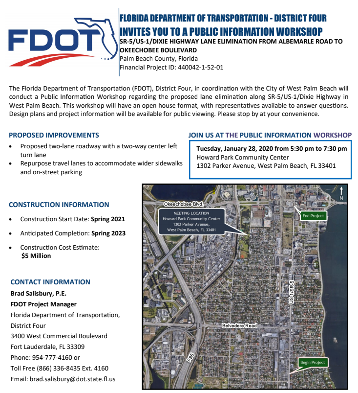
FDOT Public Meeting with West Palm Beach residents
According to what I have heard from those involved in the process the project is only 30% planned.
The project will be managed by FDOT and they are holding an Open House to discuss the project.
Construction is slated to start on Spring 2021 and be completed on Spring 2023.